Radar Altimetry Confirms Global Warming Is Affecting Polar Glaciers
 This image of South Greenland was acquired on 16 February 2006 by Envisat's Medium Resolution Imaging Spectrometer (MERIS), working in Reduced Resolution mode. (Credit: ESA)
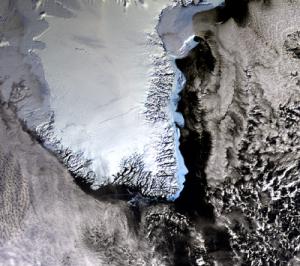
Using radar altimeter data from ESA’s ERS-1 and ERS-2, Jay Zwally, a scientist at NASA's Goddard Space Flight Center, and his colleagues mapped the height of the ice sheets and found there was a net loss of ice from the combined sheets between 1992 and 2002 and a corresponding rise in sea level.
Polar ice plays a crucial role in regulating global climate because it reflects about 80 percent of the incoming sunlight. If the ice caps over the polar ocean melt, the ocean water would absorb a large part of the radiation energy, which would lead to further melting of the ice and further warming of the climate.
According to the NASA study, published in the March edition, 20 billion net tonnes of water are added to oceans each year as a result of Greenland’s ice sheet gaining some 11 billion tonnes of water annually, while Antarctica loses about 31 billion tonnes per year.
The study found that Antarctica lost much more ice to the sea than it gained from snowfall, resulting in an increase in sea level, while the Greenland ice sheet gained more ice from snowfall at high altitudes than it lost from melting ice along its coast.
posted by Chris Irwin at 4:34 PM
![]()
![]()

0 Comments:
Post a Comment
<< Home